ZZUS11 KAKQ 221413
ZACSKY

SKYWARN Activation Notification
SKYWARN Operations Center Wakefield VA
1013 AM EDT TUE SEP 22 2026

MDZ021>024-NCZ012>017-030>032-102-VAZ048-060>062-064>070-075>090-092-
093-095>100-509>525-230213-
ACCOMACK-AMELIA-BERTIE-BRUNSWICK-CAMDEN-CAROLINE-CHARLES CITY-
CHESAPEAKE-CHOWAN-COLONIAL HEIGHTS-CUMBERLAND-DINWIDDIE-DORCHESTER-
EASTERN CHESTERFIELD-EASTERN ESSEX-EASTERN HANOVER-EASTERN HENRICO-
EASTERN KING & QUEEN-EASTERN KING WILLIAM-EASTERN LOUISA-EMPORIA-
FLUVANNA-FRANKLIN-GATES-GLOUCESTER-GOOCHLAND-GREENSVILLE-
HAMPTON/POQUOSON-HERTFORD-HOPEWELL-INLAND CURRITUCK-ISLE OF WIGHT-
JAMES CITY-LANCASTER-LUNENBURG-MATHEWS-MECKLENBURG-MIDDLESEX-NEW KENT-
NEWPORT NEWS-NORFOLK-NORTHAMPTON NC-NORTHAMPTON VA-NORTHUMBERLAND-
NOTTOWAY-OUTER BANKS CURRITUCK-PASQUOTANK-PERQUIMANS-PETERSBURG-
PORTSMOUTH-POWHATAN-PRINCE EDWARD-PRINCE GEORGE-RICHMOND-SOMERSET-
SOUTHAMPTON-SUFFOLK-SURRY-SUSSEX-VIRGINIA BEACH-WESTERN CHESTERFIELD-
WESTERN ESSEX-WESTERN HANOVER-WESTERN HENRICO AND RICHMOND CITY-
WESTERN KING & QUEEN-WESTERN KING WILLIAM-WESTERN LOUISA-WESTMORELAND-
WICOMICO-WILLIAMSBURG-WORCHESTER-YORK-
1013 AM EDT TUE SEP 22 2026

.. Activation Forecast/Status Report ..

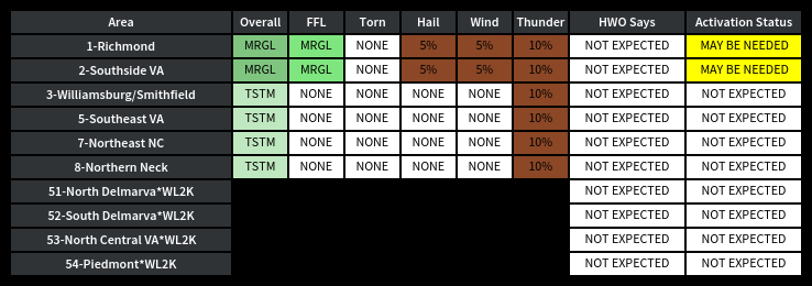
Area 1  ..Richmond Metro ..................  Not Expected
Area 2  ..Southside VA ....................  Not Expected
Area 3  ..VA Peninsula/Smithfield .........  Not Expected
Area 5  ..Southeast VA ....................  Not Expected
Area 7  ..Northeast NC ....................  Not Expected
Area 8  ..Northern Neck ...................  Not Expected
Area 11 ..DMR ID 3224947 ..................  Not Expected
Area 51 ..North Delmarva*WL2K .............  Not Expected
Area 52 ..South Delmarva*WL2K .............  Not Expected
Area 53 ..North Central VA*WL2K ...........  Not Expected
Area 54 ..Piedmont*WL2K ...................  Not Expected

.. Discussion ..

Hazardous Weather Outlook
National Weather Service Wakefield VA
521 AM EDT Tue Sep 22 2026

   Coastal Flood Advisory.
   Coastal Flood Watch.

Severe Weather is not expected over the next 24 - 36 hours.

.SPOTTER INFORMATION STATEMENT...

Spotter activation is not expected at this time.


.. Responder Discussion ..

Weather-related activation of the SKYWARN Radio Desk is not expected
over the next 24 to 36 hours.

&&

DISCLAIMER:  THIS IS NOT AN OFFICIAL PRODUCT OF THE NATIONAL
WEATHER SERVICE OR ANY OTHER UNITED STATES GOVERNMENT AGENCY.

$$

WZ4K